|  | Antarctic Moho Compilation of AN-MohoWe collected crustal thickness and/or Moho depth data from previous seismic studies (not including surface wave studies), and made a compilation of ANtarctic Moho positions (AN-Moho), under the evaluation of the quality of Moho depths. Considering that the crustal thickness or Moho depth given in previous studies may be variably defined, we corrected all thickness data to the same crustal thickness definition. Therefore, slight differences are evident between the data of our AN-Moho as compared with previous compilations and also data presented in previous studies because of different definitions. Moho depths in the compilation of AN-Moho for Antarctica is shown in Figure 1 (= Figure 4 in An et al. [2015a]). All the Moho depths and the previous studies that the Moho depths come from are listed in Table 1 (= Table S1 in An et al. [2015a]). It is noted that  the Moho depth in Table 1 is from sea level to the Moho discontinuity, but crustal thickness is from the solid surface. More details of how this compilation was constructed can be found in a supplementary section to:
     An Meijian, Douglas Wiens, Zhao Yue, Feng Mei, Andrew A. Nyblade, Masaki Kanao, Li Yuansheng, Alessia Maggi, Jean-Jacques Lévêque, 2015a, S-velocity Model and Inferred Moho Topography beneath the Antarctic Plate from Rayleigh Waves. J. Geophys. Res., 120(1),359–383, doi:10.1002/2014JB011332.CORRECTION on May 19, 2021:  Typos in longitudes of WRS* stations in Ross Sea, which are found by Dr. Renata Constantino. The correction can be found in a comparison on the Moho (circles) in Ross Sea in the below Figure 1 with those in Fig. 4 in An et al. [2015a]. Due to the Typos, Moho information from some WRS* stations in Ross Sea are not used in the construction of the initial reference model in An et al. [2015a]. 
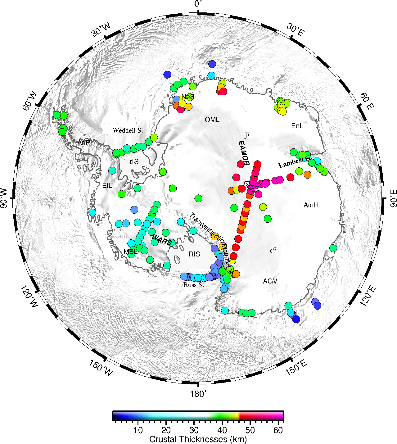
          Figure 1. Crustal thicknesses in the compilation of AN-Moho for Antarctica. Typos in longitude of WRS* stations in Ross Sea in Figure 4 in An et al. [2015a] were corrected in this figure. [download PDF]
         
 
        Table 1. Crustal thicknesses in the compilation of AN-Moho [An et al., 2015a](Typos in longitude of WRS* stations in Ross Sea were corrected in this table)


                    | Name | Longitude (°) | Latitude (°) | Crustal thickness (km) (from the soild surface)
 | Moho depths(km) (from sea level)
 | Sources |  
                    | 9169 | -6.02 | -75 | 45.0 | 42.3 | 1 |  
                    | 9172 | -9.7 | -73.6 | 44.0 | 42.6 | 1 |  
                    | 96100B | 5.9 | -67.7 | 12.0 | 16.0 | 2 |  
                    | 96100E | 6.1 | -69.7 | 23.0 | 25.0 | 2 |  
                    | 96110B | -14.1 | -69 | 10.0 | 14.0 | 2 |  
                    | 96110E | -12.5 | -73.5 | 21.0 | 23.0 | 2 |  
                    | A | 67 | -72 | 32.0 | 32.0 | 3


                            ,


                                    4 |  
                    | AMERY | 73.85 | -69.71 | 30.0 | 30.0 | 3


                            ,


                                    4 |  
                    | AN01 | 166.92 | -77.19 | 20.0 | 19.8 | 5 |  
                    | AN05 | 163.96 | -77.69 | 18.0 | 17.8 | 5 |  
                    | AN08 | 160.15 | -77.54 | 40.0 | 37.9 | 5 |  
                    | AN09 | 162.17 | -77.93 | 34.0 | 32.8 | 5 |  
                    | AN10 | 162.83 | -77.63 | 32.0 | 31.3 | 5 |  
                    | AWI2-4 | -13.09 | -74.5 | 45.9 | 45.0 | 6 |  
                    | B | 78.2 | -68.77 | 34.0 | 34.0 | 3


                            ,


                                    4 |  
                    | BEAVER | 68.34 | -70.75 | 30.0 | 30.0 | 3


                            ,


                                    4 |  
                    | BT01 | 166.563 | -71.112 | 25.0 | 23.3 | 7 |  
                    | BT05 | 158.928 | -69.89 | 31.0 | 29.5 | 7 |  
                    | BT06 | 157.337 | -69.514 | 32.0 | 31.4 | 7 |  
                    | BT07 | 155.03 | -69.245 | 31.0 | 30.0 | 7 |  
                    | BVLK | 68.17 | -70.8 | 33.0 | 32.9 | 8 |  
                    | BYRD | -119.473 | -80.0168 | 26.75 | 25.2 | 9 |  
                    | BYRD | -119.5466 | -80 | 27.0 | 25.5 | 10 |  
                    | C | 69.09 | -71.55 | 24.0 | 24.0 | 3


                            ,


                                    4 |  
                    | CASE | 160.1262 | -80.4481 | 27.8 | 27.0 | 11 |  
                    | CASEY | 110.31 | -66.17 | 30.0 | 30.0 | 12 |  
                    | CBOB | 163.1707 | -77.0342 | 20.1 | 20.0 | 11 |  
                    | CBRI | 166.4266 | -77.2516 | 18.3 | 18.0 | 11 |  
                    | CCRZ | 169.0947 | -77.5166 | 19.8 | 19.0 | 11 |  
                    | CHNA | 77.013 | -78.677 | 46.8 | 43.3 | 13 |  
                    | CHNB | 76.976 | -77.1744 | 57.5 | 54.5 | 13 |  
                    | CLRK | -141.8485 | -77.3231 | 30 | 29.0 | 9 |  
                    | CPHI | 162.6484 | -75.0745 | 22.2 | 22.0 | 11 |  
                    | CRES | 64.17 | -72.66 | 33.0 | 31.6 | 8 |  
                    | CTEA | 160.7643 | -78.9439 | 21.3 | 20.0 | 11 |  
                    | D000 | 298.5 | -74.86 | 37.0 | 37.0 | 14 |  
                    | D100 | 301 | -75.45 | 35.0 | 35.0 | 14 |  
                    | D200 | 304 | -76.06 | 33.0 | 33.0 | 14 |  
                    | D320 | -52.5 | -76.8 | 32.0 | 32.0 | 14 |  
                    | D420 | -49 | -77.2 | 30.0 | 30.0 | 14 |  
                    | D500 | -47 | -77.7 | 29.0 | 29.0 | 14 |  
                    | D640 | -41 | -77.8 | 32.0 | 32.0 | 14 |  
                    | D | 72.38 | -69.49 | 24.0 | 24.0 | 3


                            ,


                                    4 |  
                    | D780 | -36 | -77.8 | 41.0 | 41.0 | 14 |  
                    | DAVI | 78 | -68.7 | 39.0 | 38.9 | 8 |  
                    | DEVL | 161.9745 | -81.4757 | 18 | 17.9 | 9 |  
                    | DIHI | 159.48 | -79.8491 | 21.4 | 21.0 | 11 |  
                    | DNTW | -107.7804 | -76.4571 | 25.21 | 24.2 | 9 |  
                    | DOMEA | 77.1047 | -80.422 | 61.6 | 57.5 | 13 |  
                    | DRV | 140 | -66.8 | 28.0 | 27.6 | 15 |  
                    | DSS2 | -59.5 | -62.5 | 33.0 | 32.9 | 16 |  
                    | DSS6 | -62.5 | -64.7 | 35.0 | 34.4 | 16 |  
                    | DT154 | 77.0257 | -74.5824 | 49.3 | 46.6 | 13 |  
                    | DUFK | -53.2007 | -82.8619 | 38.4 | 37.4 | 9 |  
                    | E000 | 163.6175 | -77.6262 | 20.3 | 20.0 | 11 |  
                    | E002 | 163.0078 | -77.575 | 24.7 | 24.0 | 11 |  
                    | E004 | 162.0661 | -77.4133 | 30.7 | 30.0 | 11 |  
                    | E006 | 161.6256 | -77.3703 | 34.6 | 34.0 | 11 |  
                    | E008 | 160.5033 | -77.2817 | 37.8 | 36.0 | 11 |  
                    | E010 | 160.086 | -77.1847 | 39.0 | 37.2 | 17


                            ,


                                    18 |  
                    | E012 | 159.326 | -77.0461 | 40.6 | 38.7 | 18 |  
                    | E018 | 157.224 | -76.8234 | 40.7 | 38.6 | 18 |  
                    | E020 | 156.547 | -76.7295 | 45.2 | 43.0 | 18 |  
                    | E024 | 155.238 | -76.5394 | 45.6 | 43.4 | 18 |  
                    | E028 | 154.039 | -76.3075 | 45.6 | 43.3 | 18 |  
                    | E030 | 153.379 | -76.2511 | 45.5 | 43.2 | 18 |  
                    | EAGLE | 77.0448 | -76.4154 | 58.4 | 55.6 | 13 |  
                    | ERS-11 | -174.445 | -77.12 | 17.5 | 18.0 | 19 |  
                    | ERS-13 | -173.637 | -77.1217 | 17.5 | 18.0 | 19 |  
                    | ERS-17 | -172.027 | -77.1217 | 18.5 | 19.0 | 19 |  
                    | ERS-20 | -170.813 | -77.1217 | 19.5 | 20.0 | 19 |  
                    | ERS-23 | -169.61 | -77.1217 | 21.5 | 22.0 | 19 |  
                    | ERS-3 | -178.583 | -77.12 | 23.4 | 24.0 | 19 |  
                    | ERS-5 | -176.99 | -77.1167 | 23.4 | 24.0 | 19 |  
                    | ESPZ | 301.6 | -63.7 | 37.0 | 36.4 | 20 |  
                    | FALL | -143.6284 | -85.3066 | 24 | 23.7 | 9 |  
                    | FISH | 162.5652 | -78.9276 | 17 | 16.7 | 9 |  
                    | FISHER | 67.39 | -71.52 | 39.0 | 38.4 | 8 |  
                    | GM01 | 104.7291 | -83.9858 | 34.5 | 31.2 | 21 |  
                    | GM02 | 97.5815 | -79.4251 | 42.3 | 38.6 | 21 |  
                    | GM03 | 85.9439 | -80.2169 | 56.0 | 52.1 | 21 |  
                    | GM04 | 61.1124 | -82.9997 | 51.5 | 47.7 | 21 |  
                    | GM05 | 51.1588 | -81.1841 | 50.2 | 46.4 | 21 |  
                    | GROV | 75 | -72.9 | 40.0 | 38.0 | 8 |  
                    | HOWD | -86.7694 | -77.5285 | 37 | 35.5 | 9 |  
                    | ISDE | -134.9935 | -80 | 28.0 | 27.4 | 10 |  
                    | J01-SP1 | 41.2 | -70.2 | 41.0 | 40.0 | 22 |  
                    | J01-SP2 | 41.5 | -69.8 | 41.0 | 40.0 | 22 |  
                    | J01-SP5 | 42.4 | -69.25 | 41.0 | 40.0 | 22 |  
                    | J01-SP6 | 42.7 | -69.08 | 41.0 | 40.0 | 22 |  
                    | J01-SP7 | 42.95 | -68.7 | 41.0 | 40.0 | 22 |  
                    | J99-S1 | 40.06 | -69.04 | 38.0 | 37.0 | 23 |  
                    | J99-S2 | 40.65 | -69.06 | 40.0 | 39.0 | 23 |  
                    | J99-S3 | 41.3 | -69.3 | 41.0 | 40.0 | 23 |  
                    | J99-S4 | 42 | -69.6 | 42.0 | 41.0 | 23 |  
                    | J99-S5 | 42.6 | -69.8 | 43.5 | 42.0 | 23 |  
                    | J99-S6 | 43.4 | -70.2 | 45.0 | 43.0 | 23 |  
                    | JNCT | 157.901 | -76.9313 | 38.0 | 35.8 | 18 |  
                    | LONW | 152.735 | -81.3466 | 45 | 43.5 | 9 |  
                    | LT892 | 77.767 | -71.6708 | 45.7 | 43.5 | 13 |  
                    | M450 | 165.4 | -77.75 | 21.0 | 21.0 | 24 |  
                    | MAGL | 162.4083 | -76.1381 | 23.0 | 23.0 | 11 |  
                    | MBL | -130.2241 | -78.093 | 25.0 | 23.4 | 10 |  
                    | MECK | -72.1849 | -75.2807 | 26.5 | 25.4 | 9 |  
                    | MILR | 156.2517 | -83.3063 | 45 | 43.1 | 9 |  
                    | MINN | 166.88 | -78.5504 | 20.5 | 20.0 | 11 |  
                    | MPAT | -155.022 | -78.0297 | 27.5 | 27.0 | 9 |  
                    | MTM | -100.0123 | -79.496 | 21.0 | 19.0 | 10 |  
                    | MUC6-8 | -11.065 | -75.25 | 53.1 | 51.0 | 6 |  
                    | MZH | 44.3 | -70.1 | 44.0 | 42.0 | 23


                            ,


                                    25 |  
                    | N000 | 160.378 | -76.0088 | 32.8 | 31.1 | 18 |  
                    | N020 | 155.818 | -77.4678 | 40.5 | 38.2 | 18 |  
                    | N036 | 151.278 | -78.5508 | 44.0 | 41.7 | 18 |  
                    | N044 | 148.616 | -79.0692 | 47.0 | 44.7 | 18 |  
                    | N060 | 142.595 | -80.0001 | 47.9 | 45.5 | 18 |  
                    | N076 | 135.434 | -80.8062 | 48.0 | 45.5 | 18 |  
                    | N092 | 126.98 | -81.4593 | 46.6 | 43.8 | 18 |  
                    | N100 | 122.61 | -81.6525 | 45.5 | 42.6 | 18 |  
                    | N108 | 117.605 | -81.8795 | 47.0 | 43.9 | 18 |  
                    | N116 | 112.571 | -82.0098 | 45.1 | 41.9 | 18 |  
                    | N124 | 107.6406 | -82.0745 | 47.9 | 44.5 | 21 |  
                    | N132 | 101.9534 | -82.0751 | 45.3 | 41.9 | 21 |  
                    | N140 | 96.7692 | -82.0086 | 49.3 | 45.7 | 21 |  
                    | N156 | 86.5045 | -81.6726 | 46.3 | 42.4 | 21 |  
                    | N165 | 81.7604 | -81.4084 | 56.5 | 52.5 | 21 |  
                    | N173 | 77.4736 | -81.1122 | 59.2 | 55.2 | 21 |  
                    | N182 | 73.1898 | -80.7363 | 57.8 | 53.7 | 21 |  
                    | N190 | 69.431 | -80.3275 | 51.5 | 47.6 | 21 |  
                    | N198 | 65.9607 | -79.8597 | 53.4 | 49.6 | 21 |  
                    | N206 | 62.8556 | -79.3947 | 50.3 | 46.6 | 21 |  
                    | N215 | 59.9943 | -78.9045 | 47.9 | 44.4 | 21 |  
                    | NOVO | 11.835 | -70.776 | 42.0 | 41.8 | 6 |  
                    | OND | -125.7358 | -80.7456 | 28.0 | 26.9 | 10 |  
                    | P061 | 77.2238 | -84.4996 | 46.1 | 42.6 | 21 |  
                    | P071 | 77.3347 | -83.6465 | 43.0 | 39.4 | 21 |  
                    | P080 | 77.364 | -82.8054 | 48.0 | 44.2 | 21 |  
                    | P116 | 77.0451 | -79.5669 | 56.7 | 52.8 | 21 |  
                    | P124 | 77.657 | -78.8718 | 58.9 | 55.3 | 21 |  
                    | PECA | -68.5527 | -85.6124 | 37 | 35.5 | 9 |  
                    | PMSA | 296 | -64.8 | 40.0 | 39.8 | 20 |  
                    | **PMSA | -64 | -64.8 | 36.0 | 36.0 | 15 |  
                    | REIN | 72.55 | -70.45 | 33.0 | 32.9 | 8 |  
                    | RIS51 | -61 | -74.7 | 33.0 | 33.0 | 26 |  
                    | RIS56 | -55 | -75.8 | 27.0 | 27.0 | 26 |  
                    | SAE33B | -12.5 | -71.5 | 32.0 | 32.0 | 6


                            ,


                                    27 |  
                    | SAE33E | -7.2 | -70.7 | 32.0 | 32.0 | 6


                            ,


                                    27 |  
                    | SAE34B | -10.5 | -71 | 33.0 | 33.0 | 6


                            ,


                                    27 |  
                    | SAE34E | -4.8 | -73.4 | 41.0 | 39.0 | 6


                            ,


                                    27


                        ;
                            
                                
                                1 |  
                    | SBA | 166.7573 | -77.8491 | 21.0 | 21.0 | 11 |  
                    | SBA | 166.757 | -77.8491 | 21.0 | 21.0 | 5 |  
                    | SDM | -148.85 | -81.6148 | 27.0 | 26.3 | 10 |  
                    | SILY | -125.966 | -77.1332 | 32.8 | 30.7 | 9 |  
                    | SIPL | -148.9555 | -81.6405 | 28.03 | 27.4 | 9 |  
                    | SNAA | -2.838 | -71.671 | 40.0 | 39.2 | 6 |  
                    | SPA | 0 | -90 | 34.0 | 31.2 | 10 |  
                    | ST01 | -98.7419 | -83.2279 | 30.24 | 28.2 | 9 |  
                    | ST02 | -109.1243 | -82.069 | 34.24 | 32.5 | 9 |  
                    | ST03 | -113.1504 | -81.4065 | 26.53 | 24.9 | 9 |  
                    | ST04 | -116.5782 | -80.715 | 23.76 | 22.2 | 9 |  
                    | ST06 | -121.8196 | -79.3316 | 24.8 | 23.3 | 9 |  
                    | ST07 | -123.7953 | -78.6387 | 26.21 | 24.6 | 9 |  
                    | ST08 | -125.5313 | -77.9576 | 26.8 | 25.0 | 9 |  
                    | ST09 | -128.4734 | -76.5309 | 31.74 | 29.5 | 9 |  
                    | ST10 | -129.7489 | -75.8143 | 29.83 | 28.1 | 9 |  
                    | ST12 | -123.816 | -76.897 | 24.02 | 21.8 | 9 |  
                    | ST13 | -130.5139 | -77.5609 | 32.18 | 30.3 | 9 |  
                    | ST14 | -134.0802 | -77.8378 | 28.93 | 27.3 | 9 |  
                    | STC | -136.4061 | -82.3575 | 31.0 | 30.5 | 10 |  
                    | SURP | -171.2018 | -84.7199 | 26.5 | 26.1 | 9 |  
                    | THUR | -97.5606 | -72.5301 | 24.1 | 23.9 | 9 |  
                    | TNV | 164.12 | -74.7 | 22.1 | 22.0 | 11 |  
                    | UPTW | -109.0396 | -77.5797 | 22.39 | 21.1 | 9 |  
                    | VNDA | 161.8456 | -77.5139 | 35.6 | 35.0 | 11 |  
                    | **VNDA | 161.846 | -77.5139 | 35.0 | 34.4 | 5


                            ,


                                    17 |  
                    | **VNDA | 161.853 | -77.5172 | 35.3 | 34.7 | 18 |  
                    | VOSTOK | 106.48 | -78.28 | 30.0 | 26.5 | 28 |  
                    | **VOSTOK | 106.48 | -78.28 | 35.0 | 31.5 | 29 |  
                    | WA-AM | 131.5 | -64 | 18.0 | 21.0 | 30 |  
                    | WA-AN | 132 | -63.2 | 12.0 | 16.3 | 30 |  
                    | WA-BM | 141 | -65.1 | 16.0 | 18.7 | 30 |  
                    | WA-BN | 141 | -64.1 | 7.0 | 10.6 | 30 |  
                    | WA-BS | 141 | -65.6 | 23.0 | 24.1 | 30 |  
                    | WAIS | -111.7776 | -79.4181 | 25.57 | 23.8 | 9 |  
                    | WEIGEL | -9.622 | -74.275 | 44.0 | 42.5 | 6 |  
                    | WHIT | -104.3867 | -82.6823 | 31.5 | 30.2 | 9 |  
                    | WILS | -80.5587 | -80.0396 | 30 | 29.3 | 9 |  
                    | WM72 | 11.524 | -72.144 | 50.0 | 47.4 | 6 |  
                    | WM73 | 11.562 | -71.437 | 45.0 | 43.6 | 6 |  
                    | WM79 | 13.215 | -72.04 | 51.0 | 48.6 | 6 |  
                    | WNDY | -119.4129 | -82.3695 | 23.17 | 22.2 | 9 |  
                    | WRS-10 | 172.386 | -77.0717 | 18.3 | 19.0 | 19 |  
                    | WRS-11 | 172.788 | -77.0755 | 16.4 | 17.0 | 19 |  
                    | WRS-12 | 173.203 | -77.0892 | 14.4 | 15.0 | 19 |  
                    | WRS-14 | 174.005 | -77.1055 | 13.5 | 14.0 | 19 |  
                    | WRS-17 | 175.215 | -77.1052 | 20.6 | 21.0 | 19 |  
                    | WRS-21 | 176.826 | -77.1051 | 23.6 | 24.0 | 19 |  
                    | WRS-2 | 169.226 | -77.0939 | 15.1 | 16.0 | 19 |  
                    | WRS-25 | 178.445 | -77.1214 | 23.5 | 24.0 | 19 |  
                    | WRS-29 | -179.937 | -77.1218 | 23.3 | 24.0 | 19 |  
                    | WRS-3 | 169.618 | -77.1018 | 16.1 | 17.0 | 19 |  
                    | WRS-4 | 169.986 | -77.1021 | 16.2 | 17.0 | 19 |  
                    | WRS-6 | 170.773 | -77.0716 | 18.2 | 19.0 | 19 |  
                    | WRS-7 | 171.18 | -77.0539 | 19.2 | 20.0 | 19 |  
                    | WRS-8 | 171.58 | -77.0551 | 20.3 | 21.0 | 19 |  
                    | WRS-9 | 171.988 | -77.0641 | 20.3 | 21.0 | 19 |  
                    | ZHSH | 76.3727 | -69.3747 | 38.3 | 38.3 | 13 |  
 
        All data sources in Table 1 are:


                1. Hoffmann,
                M., Eckstaller, A., Jokat, W. & Miller, H. in 
                    Workshop "East-West Antarctic Tectonics and Gondwana Breakup 60W
                    to 60E" at ISAES IX meeting, September 8-12
                   (Potsdam, 2003).


                2. Jokat,
                W., Ritzmann, O., Reichert, C. & Hinz, K. Deep Crustal Structure of the
                Continental Margin off the Explora Escarpment and in the Lazarev Sea, East
                Antarctica. Mar Geophys Res 25, 283-304,
                doi:10.1007/s11001-005-1337-9 (2004).


                3. Kolmakov,
                A. F., Mishenkin, B. P. & Solovyev, D. S. Deep seismic studies in East
                Antarctica. 
                    Bulletin of Soviet Antarctic
                    expedition
                , 5-15 (1975).


                4. Baranov,
                A. & Morelli, A. The Moho depth map of the Antarctica region. Tectonophysics 609, 299-313, doi:
            
        
            http://dx.doi.org/10.1016/j.tecto.2012.12.023
         (2013).


                5. Bannister,
                S., Yu, J., Leitner, B. & Kennett, B. L. N. Variations in crustal structure
                across the transition from West to East Antarctica, Southern Victoria Land. Geophysical Journal International 155, 870-880,
                doi:10.1111/j.1365-246X.2003.02094.x (2003).


                6. Bayer,
                B., Geissler, W. H., Eckstaller, A. & Jokat, W. Seismic imaging of the
                crust beneath Dronning Maud Land, East Antarctica. Geophysical Journal International 178, 860-876, doi:10.1111/j.1365-246X.2009.04196.x (2009).


                7. Agostinetti,
                N. P., Amato, A., Cattaneo, M. & Di Bona, M. Crustal structure of northern
                Victoria Land from receiver function analysis. Terra Antarctica 11,
                5-14 (2004).


                8. Reading,
                A. M. The seismic structure of Precambrian and early Palaeozoic terranes in the
                Lambert Glacier region, East Antarctica. 
                    Earth
                    and Planetary Science Letters
                 244,
                44-57, doi:
            
        
            http://dx.doi.org/10.1016/j.epsl.2006.01.031
         (2006).


                9. Chaput,
                J. et al. The Crustal Thickness of
                West Antarctica. J. Geophys. Res.,
                submitted (2014).


                10. Winberry,
                J. P. & Anandakrishnan, S. Crustal structure of the West Antarctic rift
                system and Marie Byrd Land hotspot. Geology
                32, 977-980, doi:10.1130/g20768.1
                (2004).


                11. Lawrence,
                J. F. et al. Crust and upper mantle
                structure of the Transantarctic Mountains and surrounding regions from receiver
                functions, surface waves, and gravity: Implications for uplift models. Geochem. Geophys. Geosyst. 7, Q10011, doi:10.1029/2006gc001282
                (2006).


                12. Reading,
                A. M. The Seismic Structure of Wilkes Land/Terre Adelie, East Antarctica and
                Comparison with Australia: First Steps in Reconstructing the Deep Lithosphere
                of Gondwana. Gondwana Research 7, 21-30, doi:
            
        
            http://dx.doi.org/10.1016/S1342-937X(05)70303-8
         (2004).


                13. Feng,
                M. et al. Crustal Thicknesses along
                the Traverse from Zhongshan to Dome A in Eastern Antarctica. Chinese J. Polar Research 26, 177-185 (2014).


                14. Leitchenkov,
                G. & Kudryavtzev, G. Structure and origin of the Earth's Crust in the
                Weddell Sea Embayment (beneath the Front of the Filehner and Ronne lee Shelves)
                from deep seismic sounding data. Polarforschung
                67, 143-154 (1997).


                15. Kanao,
                M. & Shibutani, T. in 
                    Seismic Waves -
                    Research and Analysis
                   (ed
                Masaki Kanao)  237-252 (InTech,
                2012).


                16. Guterch,
                A., Grad, M., Janik, T., Perchuć, E. & Pajchel, J. Seismic studies of the
                crustal structure in West Antarctica 1979–1980—Preliminary results. Tectonophysics 114, 411-429, doi:
            
        
            http://dx.doi.org/10.1016/0040-1951(85)90024-1
         (1985).


                17. Finotello,
                M., Nyblade, A., Julia, J., Wiens, D. & Anandakrishnan, S. Crustal Vp–Vs
                ratios and thickness for Ross Island and the Transantarctic Mountain front,
                Antarctica. 
                    Geophysical Journal
                    International
                 185, 85-92,
                doi:10.1111/j.1365-246X.2011.04946.x (2011).


                18. Hansen,
                S. E. et al. Using S wave receiver
                functions to estimate crustal structure beneath ice sheets: An application to
                the Transantarctic Mountains and East Antarctic craton. Geochem. Geophys. Geosyst. 10,
                Q08014, doi:10.1029/2009gc002576 (2009).


                19. Trey,
                H. et al. Transect across the West
                Antarctic rift system in the Ross Sea, Antarctica. Tectonophysics 301,
                61-74, doi:
            
        
            http://dx.doi.org/10.1016/S0040-1951(98)00155-3
         (1999).


                20. Vuan,
                A. Joint Inversion of Receiver Function of Teleseismic Body Waves and Local
                Group Velocity Dispersion Curves beneath ESPZ and PMSA Stations (Antarctic
                Peninsula). Terra Antarctica 8, 49-54 (2001).


                21. Hansen,
                S. E. et al. Crustal structure of the
                Gamburtsev Mountains, East Antarctica, from S-wave receiver functions and
                Rayleigh wave phase velocities. 
                    Earth and
                    Planetary Science Letters
                 300,
                395-401, doi:10.1016/j.epsl.2010.10.022 (2010).


                22. Miyamachi,
                H. et al. A refraction and wide-angle
                reflection seismic exploration in JARE-43 on the Mizuho Plateau, East
                Antarctica. Polar Geoscience 16, 1-21 (2003).


                23. Yoshii,
                K., Ito, K., Miyamachi, H. & Kanao, M. Crustal structure derived from
                refractions and wide-angle reflections in the Mizuho Plateau, East Antarctica. Polar Geoscience 17, 112-138 (2004).


                24. McGinnis,
                L. D., Bowen, R. H., Erickson, J. M., Allred, B. J. & Kreamer, J. L.
                East-West Antarctic boundary in McMurdo sound. Tectonophysics 114,
                341-356, doi:
            
        
            http://dx.doi.org/10.1016/0040-1951(85)90020-4
         (1985).


                25. Ikami,
                A. & Ito, K. Crustal structure in the Mizuho Plateau, East Antarctica, by a
                two-dimensional ray approximation. 
                    Journal
                    of Geodynamics
                 6, 271-283, doi:
            
        
            http://dx.doi.org/10.1016/0264-3707(86)90044-X
         (1986).


                26. Jokat,
                W., Fechner, N. & Studinger, M. in 
                    The
                    Antarctic Region: Geological Evolution and Processes
                  (ed C.A. Ricci) 453-459 (Terra Antartica Publication,
                1997).


                27. Kudryavtzev,
                G. A., Butzenko, V. V. & Kadmina, I. N. in Sixth international sysmposium on Antarctic earth sciences    330-335 (National
                Institute for Polar Research, 1991).


                28. Studinger,
                M. et al. Geophysical models for the
                tectonic framework of the Lake Vostok region, East Antarctica. Earth and Planetary Science Letters 216, 663-677 (2003).


                29. Isanina,
                E. V., Krupnova, N. A., Popov, S. V., Masolov, V. N. & Lukin, V. V. Deep
                structure of the Vostok Basin, East Antarctica as deduced from seismological
                observations. Geotectonics 43, 221-225,
                doi:10.1134/s0016852109030042 (2009).


                30. Eittreim,
                S. L. Transition from continental to oceanic crust on the Wilkes-Adelie margin
                of Antarctica. 
                    Journal of Geophysical
                    Research: Solid Earth
                 99,
                24189-24205, doi:10.1029/94jb01903 (1994).
            
        
     |